 |
| Heading up the Two Dollar trail |
Eighteen Senior Trailblazers planned to drive to Gates Overlook and hike down the Rock Trail and up to Raptor Ridge. Unfortunately, the gate was closed on Cleator Road, blocking us from the Overlook. Instead, we decided to take the Two Dollar trail off the same road and hike instead to Burnout Point and Gates Overlook for lunch, then return. Since we were parked right at the Two Dollar trailhead, it made sense.
 |
| Victoria and waterfall |
It was overcast when we started out, with dense fog having moved in during the night. It was cool in Bellingham yesterday, while the Seattle area basked in the mid-70s. Today it was our turn, with warm temperatures and, when the skies cleared, lots and lots of sunshine.
 |
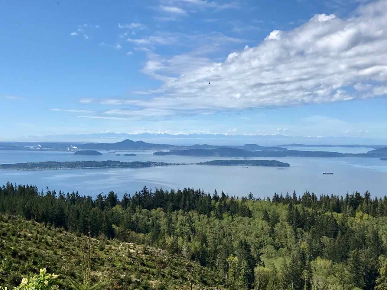
| What a view from Burnout Point |
We made it up to Burnout Point by mid-morning and admired the view. Al suggested that we have a quick snack and then head to Gates Overlook for lunch We all agreed, as nobody was in a hurry to leave this wonderful view. You are looking at the Salish Sea and the Olympic Mountains in the distance. The remnants of the clouds quickly burned off.
 |
| Let's take some pictures |
As we settled in for a snack, the cameras came out everywhere. When we visited this place a few months ago, it was not exactly raining but we didn't have much of a view. Today, however, it was not only sunny and warm, you could see for miles and miles.
 |
| On the Rock Trail |
The we headed down the Lost Lake trail and up the Rock Trail to Gates Overlook. This favorite part of the hike, the Rock Trail, was the first time for a few of today's Trailblazers. It climbs rather steeply up to the Overlook, but almost 200 steps have been constructed into the trail to make it easier to navigate. I myself would rather travel up those stairs than down.
 |
| The new view from Gates Overlook |
And then we reached Gates Overlook for our lunch spot, right at noon. You can see Chuckanut Bay below in the distance, and we noticed that someone, probably the Forest Service, has chopped down several trees to give us a much better view.
 |
| One of the three picnic tables we shared |
We could tell that the gate was still not open, because no cars made it up there to join us. We speculated that they are grading the road and getting it ready for more activity. The view enhancement project might have been part of the reason for the closure, too.
 |
| Heading back to the cars |
No matter the reason, our substitute hike was perfect. As you can see from this picture, we had plenty of sunshine streaming through the trees as we headed back down the Two Dollar trail. It felt like our first summer day, with the temperature in the low 70's and no need for our rain gear at all, or even gloves! A simply lovely day.
 |
| Our trailhead today |
I don't have any idea where this trail got its name, but we traveled up it for the first time (for me) this February. You can read about it
here, if you're interested. Today was a MUCH nicer day, and although I'm really tired, I'm very glad I went today and have plenty of time to relax and recover. We traveled over nine miles and gained and lost 2,300 feet of elevation. It wasn't the hike we planned today. It was better!
:-)


Beautiful! I favor the waterfall photo.
ReplyDeleteThis comment has been removed by the author.
ReplyDeletePs...sorry ... double posted comment. So, I will say here...love the photo of the lilacs in your previous post.
DeleteThat trail is worth MUCH more than two dollars. Thank you, again, for taking my sendentary self along.
ReplyDeleteOh, good. A dry, sunny, warm day for a hike, for a change!
ReplyDeleteWe walked in fog this morning, gardened in sunshine, or in my case, in the shade, and finished up about 3:45, just as the first BOOM rumbled overhead in a now dark sky. We are having quite the wave of thunder storms now. Very dramatic!
What a great substitute hike. 70 ? Too hot for hiking.
ReplyDeleteWhat a pretty view from Burnout Point! I am so glad you had a good hike! :)
ReplyDeleteSounds like an awesome hike. Sunshine would certainly help! Enjoyed figuring out all those trails on Google Maps, compared to where we drove. That first distant view now looks a little familiar!
ReplyDeleteSounds like an enjoyable hike, DJan. Your hikes are so much more picturesque (and healthier with all that fresh air and sunshine) than our walks at the Mall. Thanks for taking us along virtually.
ReplyDeleteThose are some spectacular views! Glad you had a good weather day for your hike.
ReplyDeleteSome of the names of places and trails there crack me up. Looks like it was a wonderful day to hike. Perfect, in fact. :)
ReplyDeleteWhat a pleasant hike. I love your photos, which seem clear and bright due to the sunshine.
ReplyDeleteI love the names of the trails, mountains and lakes. I smile every time I read them, like Chuckanut. Colourful names for sure! I bet there are great stories behind them!
ReplyDeleteI give your area credit for the most creative names of trails, lakes and views. They always make me smile also. So good to see shirtsleeves. Wow, that had to be wonderful.
ReplyDeleteThat was quite a walk with some tough inclines but the vistas from the top are spectacular. Just keep the photos coming. I love being on these walks with you.
ReplyDeleteYou were so lucky to have such a beautiful day for this hike. I can just imagine how many elevation (stairs) and steps this would have racked up on a Fitbit.
ReplyDelete